


: A sophisticated cyber threat")
Another weekend, another storm for Atlantic Canada. It’s an unlucky streak of winter storms for the East Coast, with conditions of the current system expected to linger through Saturday. The storm has already knocked out power to tens of thousands and travel has been impacted in Nova Scotia due to an extended period of freezing rain and ice accretion. Meanwhile, New Brunswick, P.E.I., and a good portion of Newfoundland are dealing with heavy snowfall, with the potential for some to get more than 40 cm through Saturday. The good news is the Maritimes will see a gradual improvement in conditions Saturday morning as the snow and freezing rain begins to subside. On top of that, the Avalon Peninsula is facing a flood risk from a round of soaking rains Saturday. More on the impacts of this latest potent system, and what’s ahead for Saturday, below.
RELATED: PHOTOS: Thousands without power as expansive storm blasts the East Coast
SATURDAY: SIGNIFICANT AND PROLONGED FREEZING RAIN AND SNOWFALL WINDS DOWN IN THE MARITIMES
After sweeping across the continent from the Rockies and Gulf Coast to the Great Lakes, this week’s winter storm is unleashing its grand finale on Atlantic Canada, with effects lingering into the weekend.
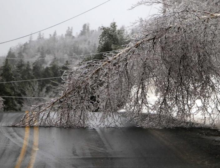
For Nova Scotia, the freezing rain took a heavy toll on large limbs and utility infrastructure Friday, leading to widespread power outages that at one point exceeded 38,000 customers. The potential remains for the tally to fluctuate through Saturday morning.

DON’T MISS: How to stay safe during a winter power outage
Parts of the immediate Atlantic coast have seen a transition to freezing rain, while southwestern Nova Scotia can expect the change overnight. So far, parts of the province has seen 16 hours of freezing rain, with possibly another eight to go before it winds down Saturday morning.
“Surfaces such as highways, roads, walkways and parking lots will become icy, slippery and extremely hazardous. Beware of branches or electrical wires that could break under the weight of ice. Extended and widespread utility outages are possible,” Environment and Climate Change Canada (ECCC) says in the freezing rain warning.
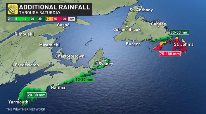
HEIGHTENED FLOOD THREAT FOR NEWFOUNDLAND’S AVALON PENINSULA
Newfoundland’s Avalon Peninsula will see a prolonged period of heavy rainfall beginning Friday evening after changing over from freezing rain.
Rain, at times heavy, will continue on Saturday until changing to snow in the overnight hours. Some of the highest rainfall totals are likely to occur over an area previously affected by flooding last weekend. Flooding and road washouts are possible once again.
Heavy downpours can cause flash floods and water pooling on roads.
Rainfall amounts of 75-100 mm is expected for the Avalon Peninsula and areas to the west of the region through Saturday. Any standing water risks a quick freeze as temperatures plummet Sunday.
Meanwhile, in other areas of the island, snow will continue through Saturday and into the evening before tapering to flurries overnight. The snow may mix with or change to ice pellets for a few hours Saturday morning and afternoon over Gander and vicinity, and northern Bonavista, as well.
Accumulations could hit 30-40+ cm in Gander and vicinity, with 20-30 cm for southwestern areas of Newfoundland.
NEW BRUNSWICK AND P.E.I. BEAR THE BRUNT OF THE HEAVIEST SNOW
Winter storm and snowfall warnings cover much of New Brunswick and P.E.I., both being the target zones for the heaviest amounts of snow by staying on the colder side of this system. The snowfall prompted the closure of schools across both provinces Friday morning, with bus and air travel services scrapped, as well.
Snow will continue to accumulate in most areas through the overnight period. Blowing snow will be possible in exposed locations, leading to reduced visibility and difficult travel. Conditions are expected to improve by early Saturday morning as snow tapers to flurries.
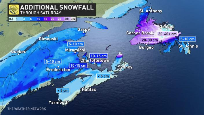
In the heaviest bands, snowfall accumulations may reach 40-60 cm through Saturday. Moncton had already received more than 40 cm by Friday afternoon, and may see another 10 cm by the time the storm moves out.
WATCH: MARITIMERS PREP FOR SLOW-MOVING STORM AS RISK OF POWE
R OUTAGES LOOM
Click here to view the video
HOW TO PREPARE FOR POWER OUTAGES AND FALLING TREES
Make sure your mobile devices are fully charged before and during the freezing rain. If the power goes out, avoid using your device unless absolutely necessary. If you have flashlights, put them in an easily accessible spot (along with extra batteries) so you can find your way around in the dark without relying on a smartphone’s flashlight feature.
Cold temperatures filtering into the region after the storm will make extended power outages especially tough. Seal up any windows and doors that could let out excess heat. Never use grills, generators, or outdoor heaters indoors or too close to a structure. This kind of misuse could lead to a life-threatening risk for carbon monoxide poisoning.
Also, make a note of any tall trees or large tree limbs that could fall into your home if they’re weighed down by significant ice accretion. Trees falling into homes is a regular source of injuries during and after winter storms. If there’s a tree that looms large overhead, consider avoiding those rooms until the ice falls or melts.
Thumbnail courtesy of Dawn Gunn, taken in Digby, N.S., Feb. 4, 2022.
Stay tuned to The Weather Network for all the latest on this major winter storm.


